|
|
|
|
|
|
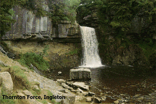
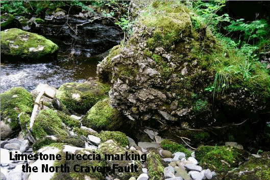
Field trip to Ingleton Falls on Sunday 11 July 2010 Leader: Gordon Liddle The aim of the walk was to examine the evidence and effects of the of the North and South Craven Faults on the southern margin of the Askrigg Block, giving rise to steeply dipping and strongly deformed turbidites, which also affected the overlying limestones. Later glacial features were also looked at. In order to appreciate the features seen it was important to consider them in the context of the geological history. The turbidites, the oldest rocks in the region known as the Ingleton Group, probably date back to the early Ordovician, and are deep oceanic sandstones and siltstones which were later deformed and compressed during the coming together of the three ancient landmasses of Avalonia, Baltica and Laurentia, and the closure of the Iapetus Ocean. The related island arc volcanic activity gave rise to subaerial volcanic deposits in these sediments and later post-Caledonian crustal extension and subsidence led to a marine transgression. Further subsidence took place leading to an increased deposition of turbidites during the final closure of the Iapetus Ocean. In the early Devonian a granite intrusion caused uplift, giving rise to a subsiding graben basin to the south and the Craven Fault belt. After meeting in the car park of the Thornton Force Waterfalls Walk in Ingleton the walk begins with a traverse across the flood plain alluvial deposits of the River Twiss laid down since the last Ice Age. As we head north and cross the South Craven Fault the path begins to rise as we enter the beautiful wooded gorge of Swilla Glen, the river cutting down into the massive basement limestones of the Lower Carboniferous Coal Measures, now on the upthrow of the fault. We noted the south facing dip of the thick limestone beds, decreasing as we headed towards the core of an anticline. The limestones now formed the wall of the glen, probably once part of an ancient cave system which became unroofed. It was possible to examine the uneven upper and lower surfaces of individual beds representing a break in deposition due to isostatic sea level changes during this time. The limestones were rich in shell debris with corals common at the top of the beds indicating tropical seas. Ripple marks were visible on the undersurfaces of the overlying beds. There was evidence of solution tubes in the massive limestone, and present day springs gave rise to tufa deposits. We crossed Manor Bridge into Pecca Glen, where the river follows the North Craven Fault line. On the west bank of the river shales are faulted against calcareous limestones on the hanging wall of the fault, with an adit, the result of an earlier attempt to explore the mineralisation. Evidence of the North Craven Fault could be seen up the hillside as a series of lystric faults. The route of the path now traversed the deformed rocks of the Lower Paleozoic terrain of the Craven Inlier, where exposures of turbidites chaotically mingle with the intensely deformed, steep dipping beds of the Ingleton slates. We passed several waterfalls, still fairly full despite the recent drought, and crossed Pecca Bridge. Here we temporarily left the path to clamber over the green-grey cleaved Ingleton Slates in a quarry beside the river. We picked our way down the scree slope of the quarry to the river in search of the narrow fault zone of the North Craven Fault, and were quite relieved when we finally stumbled across it exposed in the river bank. Here we found some spectacular fault breccia in the boulders, where, to the north of the boundary it comprised sharply angled slates, and to the south was the respective limestone breccia. We considered this short but adventurous excursion well worthwhile, and would probably not have been possible had the river been in full spate. Lunch time now called, and we finally emerged from the glen to our lunchtime venue overlooking the splendid cove formed by Thornton Force. The waterfall was sparse, reflecting the recent dry spell, but it allowed us to examine the unconformity exposed by the waterfall, where subhorizontal limestones with a conglomerate base rest on top of the more massive looking turbidites of the Ingleton Group and the steeply dipping laminated basal siltstones. The time gap represented by the unconformity between the Carboniferous and the Palaeozoic basement is indeterminate, and is emphasised by the undercutting of the limestones due to preglacial erosion. We stood on the Ingleton Group by the plunge pool and searched for a rather inconspicuous dyke we knew was there. After lunch we continued on the path upwards, over Raven Ray, a Devensian terminal moraine which once blocked a huge glacial lake occupying Kingsdale. Indeed, evidence of the preglacial river bed could still be seen as a dip which descended the western side of the moraine into the plunge pool. As we rounded the summit of Raven Ray we caught a glimpse of the spectacular limestones of Keld Head Scar in Kingsdale. At this point we turned right and crossed Raven Ray footbridge over the River Doe, following the return path of this delightful circular walk, passing Beezley Farm and Beezley Falls, admiring the cascading series of the Snow Falls, discussing some of the features of the Craven Fault belt system and its associated structures as we went. It was an interesting and well worth while walk, from both the visual and geological point of view. Kindly supplied by Mavis Gill Top of page |
|
|