|
|
|
|
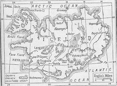
"Hotspot-ridge interaction in and around Iceland". Professor Godfrey Fitton, University of Edinburgh. 21st November 2008. November's talk focused mainly on volcanic activity and the causes of it
in Iceland. During the talk Professor Fitton explained the importance of Iceland in being able to understand more about Earth processes. Iceland's main attribute in this area is that it is effectively an above sea level section of the mid-Atlantic ridge which enables scientists, including Professor Fitton, to study at close range an area of geology that would otherwise be relatively inaccessible and costly to observe. In discussing the causes of volcanism Professor Fitton discussed the highly controversial area of the causes of intra-plate volcanism where volcanoes occur at hotspots ("areas of focused excess magmatism"). Using the Icelandic hotspot centre slightly to the south east of the mid-Atlantic ridge as an example, he discussed the relative attributes of the theory of mantle plumes (one of the most controversial theories in Earth Sciences in recent times) in hotspot areas. While also citing evidence from Hawai'i (arguably the most famous hotspot area on the planet) Professor Fitton explained that volcanism and an increase in the temperature of the mantle in these hotspot areas tend to occur in pulses. He aired the possibility that the pulses "switching on and off" could be linked to "blobs" of basalt entering the mantle via subduction zones increasing the fertility of the magma (decreasing the viscosity of the magma making eruptions more likely). After explaining all the evidence, Professor Fitton concluded that in his opinion it is reasonable to suggest that mantle plumes may be the cause of intra-plate volcanism and that one of these plumes exists underneath Iceland itself. Professor Fitton also touched on the different types of research that can be done in the area. A relatively new technology-based example was the imaging of the area using S-wave topography, which for example showed how the centre of Iceland is an area of very thick crust and that crust thickness decreases away from the centre of Iceland. Other more hands-on investigations included a £300,000 project in which Professor Fitton was one of a team of scientists who spent some time on the Irish research vessel Celtic Explorer dredging an area around Iceland - concentrating especially on the crest of the mid-Atlantic ridge where the best samples (relatively new in-situ pillow lavas) could be found. As well as providing very useful information this project also resulted in a bumper haul (nearly half a tonne in a single dredging bucket) of usually hard to get samples, which were split up and distributed among every school in Ireland. An ambitious project which Professor Fitton hopes will take place in the near future is a £4 million drilling project led by University of Southampton geochemist Dr Bramley Murton who plans to drill a series of fourteen boreholes in the area of the mid-Atlantic ridge just off South West of Iceland, including a transect cutting across the ridge itself. This talk was most interesting and informative and was suitable for anyone whether complete novices who just have an interest in geology or people who are themselves Professors. Michael Rabin, November 2008. |
|
"Tephrochronology, resilience and limits to adaptation. Lessons from the Viking settlement of the North Atlantic". Professor Andrew Dugmore,
University of Edinburgh. 12th December 2008. This talk focused mainly on how the Vikings tried to adapt to the various locations in the North Atlantic and how these events can be dated using the available evidence -geological or otherwise. One
method of dating events using geological evidence is tephrochchronology -
using tefra (volcanic ash, volcanic bombs, volcanic glass etc) observed in
layers of rock and mud to place events relative to each other.
Particularly violent eruptions that produce large quantities of tefra create
"marker horizons". For example, if evidence of a human
settlement is found between two ash layers (observed as black stripes in the
mud) of known dates then you know that the settlement was present between
those two dates. One situation where this technique was useful was when
turf used to build Viking longhouses was found to contain an ash layer. As well as dating events, much evidence (mostly non-geological) can be used to reveal parts of Viking activity / adaptation. Animal bones (the combined collection of The University of Edinburgh and their New York partners currently comprises 750 000 identified animal bones from Viking Iceland) can give details of diet. The Vikings ate tarmagan (bird) and duck eggs. Animals introduced to the area also indicate diet, the Vikings having taken many pigs to Iceland. Their impact on native species, eg the killing off of walruses for their tusks within two generations and also the killing of great auks, whose skeletons were mentioned by Professor Dugmore as being very rare. Another useful tool discussed by Professor Dugmore for dating Viking activity and movements is examining remains of charcoal production with charcoal pits able to be dated to within five years. This indicates that within twenty years of the Vikings settling in Iceland they had removed much of the woodland for charcoal production. According to Professor Dugmore some areas of woodland that remained still produce several thousand packhorses of timber each year. Theories discussed by Professor Dugmore for why the Vikings struggled in some areas include: Climate variability (including a short growing season) Professor Dugmore also noted that some areas of Iceland not populated by Vikings had a different outcome to places that Vikings did populate. A prime example is North Landn?m which still today has good quality farmland and environment whilst areas a very short distance away (that had the same landscape before the Vikings arrived) are now desolate to the extent that NASA uses them for training astronauts going to the moon. He also pointed out that environmentally the Vikings fared better in Greenland with most damage to the environment caused by glacial winds. In summing up, Professor Dugmore mentioned that even if populations adapt both socially and environmentally in ways that are sustainable for centuries they can still die out or have to move on. This can be due to disease or natural disasters (having pointed out that it is common for "bad things to happen to good landscapes"). He also revealed that some families seemed to be experts at adapting to different environments with research showing that the most prominent Viking example is the "Red" family (as in Erik the Red). Michael Rabin, December 2008. |
|
|